Almost everybody knows that before you build something, you have to get a permit. You’ve got to get plans approved, you’ve got to get the zoning in place. But not everybody knows that before you demolish something, you also need a permit.
Where to Get the Application
If you’re in Nelson Mandela Bay, the demolition application form is available online — go to nelsonmandelabay.gov.za and download it. Make sure you’re getting the latest version.
If you don’t have internet access, you can go to the building inspectorate on the fourth floor, in the building opposite the info centre — near where Treasury is, by the Lillian Diedericks building. But honestly, the easiest route is just to get it off the website.
What You Need to Submit
The application comes with a checklist, and it can all be emailed in. You’ll need:
An aerial photograph of the building to be demolished, a locality map, and elevations of the building to be demolished.
And here’s the important one: if the building is older than 60 years, you need a heritage permit before you submit — that’s an application to the provincial heritage authority, ECPHRA. That’s a whole process on its own (we’ll cover it separately). If the building is younger than 60 years, you don’t need one.
You’ll also need to provide proof of age of the building. Don’t be tempted to claim a building is younger than 60 years when it isn’t — that’s fraud, and you can get into serious trouble. I’m not exaggerating when I say jail time is a possibility.
What It Costs
It’s a flat fee — currently R641 — payable to the municipality. They’ll confirm the amount and give you payment details when you submit.
The Bottom Line
That’s the paperwork and the approvals you need in place before you demolish anything. So don’t say you didn’t know — because now I’ve told you.
It’s really not that complicated, but if you need help with this, look us up. And if you’re not in Nelson Mandela Bay, don’t think this doesn’t apply to you — every jurisdiction in South Africa has a similar process. Wherever you are in the country, you’re going to need a demolition permit.
People often come to my office asking for technical advice about developing short-stay accommodation. The questions are always the same: How do the land use rights work with the zoning? What may I or may I not do? How would the structure work? How do the foundations work? How does the drainage system handle stormwater, or get the toilets to flush?
All valid questions. But if you’re thinking of developing short-stay accommodation on your place — let’s say you’ve got a farm or some land — my advice is something different.
Be a Guest Before You Become a Host
Experience these places. As many as you can. As a visitor, as a user.
Try the five-star ones. Try sleeping under the stars. I’ve stayed in all kinds of accommodation — I’ve slept under the stars on the bank of a river, and I’ve slept in five-star hotels in Berlin. Each of those can be a great experience, because a great experience is about measuring expectation against the product — against the thing itself.
So visit as many places as you can, from the five-star right down to sleeping next to a river and everything in between, and measure your experience of each. When you then develop your own short-stay accommodation, tweak it. Add the little things. Maybe it’s something as small as a tea bag, or a box of matches to light a fire. Maybe it’s something big. But if you focus in on the experiential side, you’ll find yourself working on what’s achievable rather than dwelling on what’s lacking.
A Case in Point: Where We Stayed Last Night
The place we stayed in last night may not be for everybody — and to their credit, they advertise quite clearly on the website exactly what it is.
It’s a homebuilt structure. A bed, a double bunk behind it, a rudimentary little table, a small fireplace inside. Outside, there’s a bathroom with a shower — hot and cold water — a little basin, and a beautiful outdoor tub.
Could it be more five-star? Sure. Did I have fun having a bubble bath out in the open under the stars last night? Yes, I did.
That’s the point. Experience the rustic, the glitzy, the glamorous and the unglamorous. Out of all of it, you’ll begin to get a feel for the kind of user experience you want to offer your own guests.
The technical stuff is a dime a dozen — you can buy that in. What you can’t buy in is your own personal understanding of what you, as a human being, would want. Align your product with that, and you’re set.
The Architect’s Eye: How the Place Is Put Together
Of course, I can’t switch off the technical eye entirely. For those interested, here’s how the structure works:
The floor is OSB. The cabinets and joinery are made from decking planks. The walls are a combination of corrugated iron and hessian — hessian for the ceilings — with Flexite (a fibre cement board) along some walls. The windows are rescued steel frames, including French door windows, with light fittings from Builders Warehouse. The steps are decking board, though the plank spacing is wrong — too bouncy. External cladding is cut-off pine end strips. The roof is a very simple mono-pitch, which leaked inside last night — I don’t know why. The whole structure sits on gum poles set into a concrete pad. I don’t like that detail; it’s going to rot. There’s foam filling the gaps, and the ground level is too high in places.
None of that is meant unkindly. It’s a homebuilt place that delivers exactly the experience it promises — and that’s the lesson.
The Takeaway
Get out there and experience these places. That’s what matters. The technical knowledge can be bought in, but the feel for what makes a stay memorable — that has to come from you.
One of the most pressing challenges facing South African cities — now and for the foreseeable future — is the provision of affordable housing. We have programs for the poorest of the poor through the RDP housing scheme, and we have private sector developers building for those who earn a salary. But in between sits a significant gap, and it is this gap that social housing exists to fill.
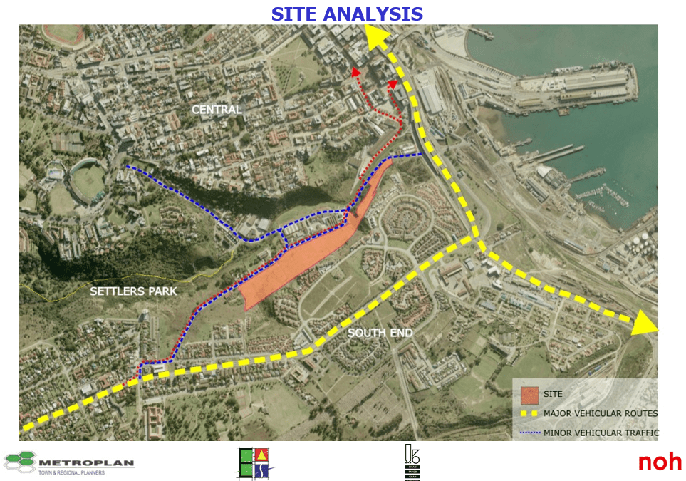
At noh Architects, we have been working on exactly this kind of project in the inner city of Nelson Mandela Bay, in the historic South End precinct. The work began as part of a larger urban design commission — a Spatial Strategic Infrastructure Framework (SSIF) for the Mandela Bay Development Agency — in collaboration with GAPP Urban Design from Johannesburg, with town planners Metroplan, environmental engineers EAS, and quantity surveyors BTKM. Out of that broader study, a specific site emerged around the Baakens River in South End.
A Site With History
South End carries a heavy history. It was once a vibrant, mixed-race neighbourhood — Nelson Mandela Bay’s equivalent of Cape Town’s District Six — before forced removals in the early 1970s left vast swathes of land vacant. Much of that land remains undeveloped to this day. Walking past it, or driving past it, that emptiness is a quiet reminder of what was lost.
But emotions aside, the technical reality is that this is a well-located, developable site — and one of the best arguments for inner-city affordable housing you could ask for.
Demand-Driven Design
Good urban design doesn’t start with a grand vision. It starts with the facts: who owns the land, what the current land use rights are, what future rights are plausible, and critically, what the demand actually is. There is no value in an architect producing a beautiful urban design proposal that bears no relationship to what people can afford or what the city actually needs.
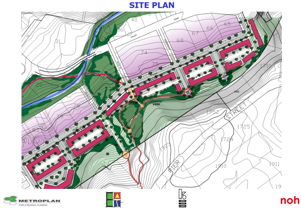
So our process involved a thorough affordability study — understanding income levels, benchmarking against existing social housing schemes, comparing public and private sector offerings, and designing unit types to match what residents can realistically pay.
Addressing the “Too Steep” Objection
The site slopes. And yes, people drive past it and say it’s undevelopable. It’s too steep, they say.
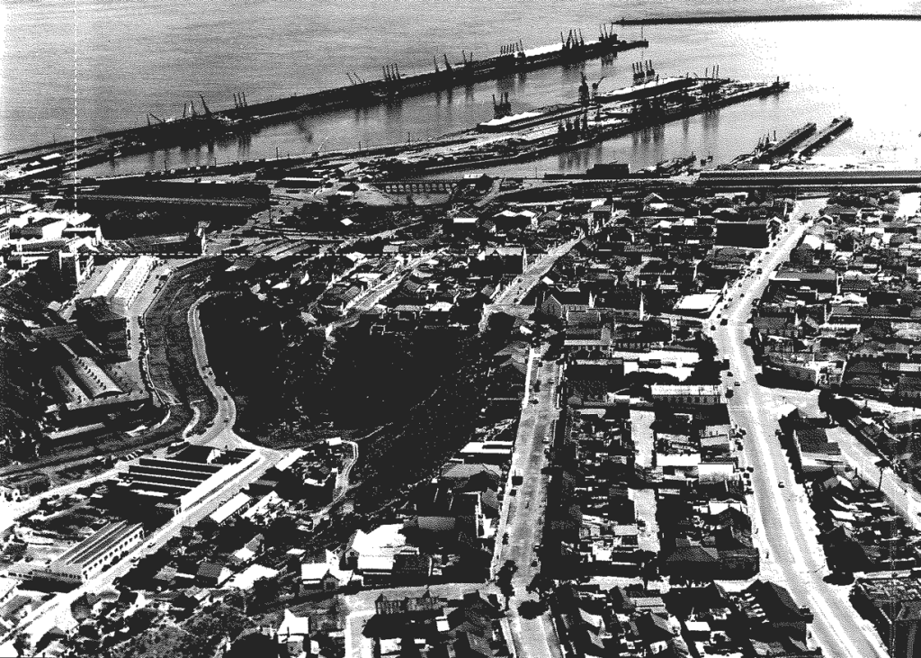
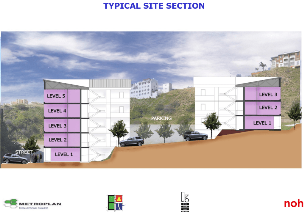
It isn’t. The historic photographs tell the story plainly: this land was fully developed before the demolitions. And it doesn’t take rocket science to see how it could be developed again. Cities all over the world have been built on slopes — Barcelona’s famous city blocks being one of the most celebrated examples. The solution is simply good design thinking: working with the topography, creating a repeating city block pattern, stepping the buildings in response to the gradient.
We do not need thousands of hectares of flat land to solve our housing problems. We need creativity, and we need to make better use of the small pockets of inner-city land that already exist.
The Case for Urban Location
Affordable housing is not just about buildings. It is about access — to jobs, to education, to public transport, to opportunities. Locating people who need employment 20 or 30 kilometres from economic activity is not a housing solution; it is a poverty trap. South End sits close to the city centre, well connected to the broader economic life of Nelson Mandela Bay. That proximity matters enormously.
Increasing residential density in well-located inner-city areas also strengthens the economic case for the city itself — more people, more activity, more viable public transport, more local commerce.
Scale: From the Door Swing to the City
This is the part of urban design that young architects especially need to internalise. The thinking required of you spans from how a door swings in a unit, to how a building sits on a block, to how an entire precinct integrates with the city’s bulk infrastructure and public transport network. Architecture and urban design are not separate disciplines — they are brothers. You cannot afford to be comfortable only at one end of the scale.
Where Things Stand
Regrettably, this project has not yet proceeded. The Mandela Bay Development Agency had its own ideas for the site, and the proposal was blocked. The land remains vacant. That is a real shame — the work is done, the feasibility is established, the design is ready. The button could still be pushed.
To colleagues at the MBDA: what happened? Why has a perfectly viable social housing project been stalled while the need for affordable housing in our city continues to grow?
This conversation needs to keep happening. We cannot design cities only for the wealthy, and we cannot limit our ambition to only the most extreme end of poverty. The gap in the middle is where a functioning city lives. It is where we need to build.
noh Architects is a Nelson Mandela Bay-based architecture practice with experience in urban design, social housing, and inner-city regeneration.
There are projects that stay with you. The Njoli Precinct Plan is one of them — a genuinely ambitious urban intervention that had the vision, the funding, and the thinking behind it, and yet never came to be.
Where It Began
The story starts in 2005, with a mayoral vision for the intersection of Njoli Road and Daku Road in Kwazakhele, Gqeberha. The original concept promoted by Mayor Faku was bold — almost theatrical — a giant dome anchoring one of the city’s busiest intersections. Over time, that idea evolved into something more grounded and arguably more powerful: a major intermodal transit node as part of what would become the IPTS, the Integrated Public Transport System.
The location made obvious sense. This intersection is a natural convergence point — people travelling from New Brighton down Njoli Street, from Motherwell down Daku Road, and onward toward Kwamagxaki. It was already functioning as an informal transit hub; the plan was to formalise and amplify what was already happening organically.
The Vision Takes Shape
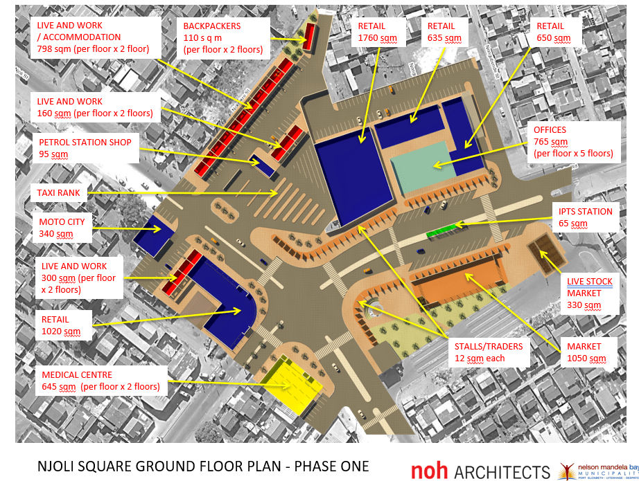
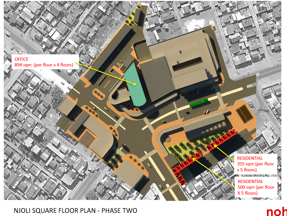
When funding was secured through the Neighbourhood Development Partnership Grant — R189 million from National Treasury — the concept was revisited and reconceptualised in earnest. Working closely with colleagues at Metroplan, particularly , the team moved away from the dome and toward something more urbane: a properly resolved four-way intersection surrounded by a mix of formal office and retail space designed to complement, not displace, the thriving informal trading already present at Njoli Square.
The design thinking was rigorous. The team engaged urban economists to model real market demand in the area. They consulted the taxi industry. They worked across all three tiers of government — national, provincial, and municipal — to understand what services each needed to deliver locally and what space that would require.
The resulting vision was genuinely mixed-use: IPTS infrastructure, formalised trader facilities, a library, an amphitheatre, civic support spaces, and — critically — national and provincial government office functions. The idea was to bring high-paying, formal employment back into a part of the city that apartheid planning had deliberately kept as a dormitory suburb, with no local economic base to speak of.
For Kwazakhele, this wasn’t just about transport. It was about economic justice.
Why It Didn’t Happen
With a compelling vision, substantial funding, multi-stakeholder buy-in, and detailed design work completed, the Njoli Precinct Plan had everything it needed to succeed.
It failed anyway.
The reason, in plain terms: poor political leadership. Not a funding gap. Not a design flaw. Not community resistance. Leadership failure at the point where decisions needed to be made and sustained.
That’s a hard thing to say, but it’s the honest analysis. And it’s worth saying clearly — because understanding why good projects fail is the only way to stop it happening again.
What Remains
The intersection is still there. The informal traders are still there. The transit demand is still there. Kwazakhele is still a dormitory suburb, still waiting for the kind of investment that would change that equation.
The Njoli Precinct Plan represents what urban design at its best can look like: technically sound, economically grounded, socially purposeful, and spatially resolved. That it was shelved is a loss — not just for the project, but for the people it was designed to serve.
I know there are a lot of people out there — many of you fresh out of university, having been promised a good career — who are looking at artificial intelligence and feeling genuinely anxious. I understand that. But I want to offer a different way of thinking about it, because I believe AI is not your enemy. AI is your friend.
Here’s why.
Technology Has Always Done This
Every significant technology that has come along has done the same thing: it has helped us see more clearly what is truly valuable and what isn’t. That clarity can feel threatening at first, but it has always, ultimately, been liberating.
Think about the ATM. When automated teller machines arrived, the assumption was that banking tellers would become obsolete. And in a narrow sense, yes — you no longer need to queue to draw cash from a person. But what actually happened is that we began to understand how valuable our time with real bankers is when it matters. The ATM freed us up to have more meaningful engagements with the people in the bank for the things that actually require human judgment, human relationship, and human trust.
Technology didn’t destroy the value of the bank. It clarified it.
The Real Thing Always Wins
Here’s another way to think about it. You can watch a rugby match from your couch in high definition, with action replays, close-ups, and expert commentary. It is, in many technical respects, a better experience than being there. And yet people still go out in the cold and the sleet to watch the game live, because they know there is something irreplaceable about being present for the real thing.
The same is true of the Mona Lisa. Technology has allowed us to reproduce that painting with extraordinary accuracy. You can see it in crisp detail on any screen. And yet people save for years, travel to Paris, and stand in long queues at the Louvre just to stand in front of the original — because they know it was painted by Leonardo da Vinci, and that knowledge changes everything. The real thing carries a weight that no reproduction can replicate.
Or consider diamonds. Most people genuinely cannot distinguish a diamond from a cubic zirconia, or even a well-cut piece of glass. And yet people value the real thing deeply, sometimes fiercely. Because authenticity matters. Because knowing something is genuine matters.
What AI Is Actually Teaching Us
AI is going to generate an enormous amount of content. Much of it will be good. Some of it will be indistinguishable from the real thing. And that is precisely what will make us understand, more clearly than ever before, what human creativity, human judgment, human presence, and human authenticity are actually worth.
AI is not going to make your skills worthless. It is going to make the right skills more valuable. It is going to sharpen our collective sense of what matters.
So yes — AI is your friend. Not because it will do your job for you, but because it will help you see, perhaps for the first time with real clarity, what your job actually is.